
Mercosur · River Logistics · Rosario · Paraguay · Uruguay
How a Deeper Paraná River Could Reshape Mercosur Trade
Argentina’s new Paraná River concession includes a staged deepening of the navigation route used by the Gran Rosario export complex. The planned change could allow ships to load more cargo upstream, reduce some completion-loading costs and alter the economics of a river system that also carries much of Paraguay’s foreign trade toward Atlantic ports.
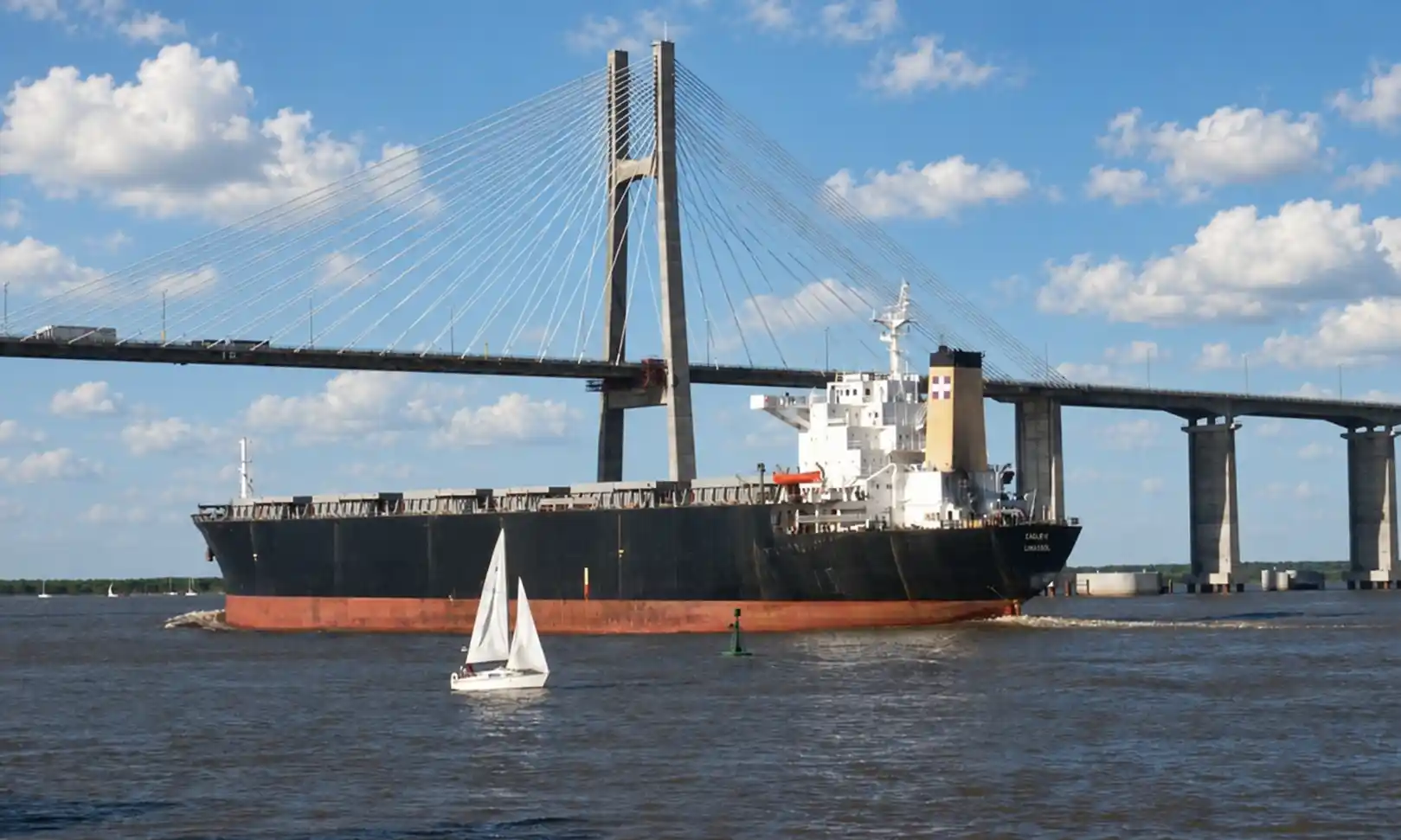
A deeper Paraná River could reduce part of the logistics penalty created when large ocean-going ships cannot load to their preferred draft at the Gran Rosario ports.
Argentina’s new 25-year concession foresees staged deepening of the main navigation route. The later target is a channel depth of 40 feet, or about 12.2 metres, between Timbúes and Paraná de las Palmas, while the Río de la Plata route toward the Atlantic is planned at 39 feet, or about 11.9 metres.
Those numbers need explanation. A 40-foot channel does not mean that a ship can automatically sail with a 40-foot draft. Vessels require clearance between the keel and the riverbed. Argentina’s ports authority has described the 40-foot channel target as roughly 38 feet, or 11.6 metres, of navigable draft.
The commercial effect therefore depends on vessel class, cargo, tolls, usable draft, river levels, waiting time and whether ships can avoid taking additional cargo at downstream ports. Because the river also carries Paraguayan cargo and connects with Uruguay’s Nueva Palmira transshipment system, the consequences extend beyond Argentina.
Core market reading: Deeper navigation can make Rosario more efficient, but the economic effect is regional. More cargo loaded upstream can change vessel utilisation, completion loading, the value of downstream ports and the cost structure facing Paraguayan river trade.
The broader geography is explained in Econosur’s existing Paraná-Paraguay Waterway analysis. That system stretches through Argentina, Bolivia, Brazil, Paraguay and Uruguay. This article looks at one narrower question: what changes economically if the lower Paraná becomes deeper?
First: What Does a 40-Foot Paraná River Channel Actually Mean?
Shipping still uses feet to describe channel depth and vessel draft, even in countries that otherwise use the metric system. The conversion makes the scale easier to understand.
| Navigation measure | Feet | Metres | What it means |
|---|---|---|---|
| Current Paraná channel reference | 36 ft | 11.0 m | ANPYN has described the current Paraná section as 36 feet deep, supporting about 34 feet of navigable draft under the stated clearance logic. |
| Current navigable draft reference | 34 ft | 10.4 m | Approximate ship draft referenced by ANPYN for the current Paraná operating configuration. |
| Stage-two Paraná target | 40 ft | 12.2 m | Planned channel depth between Timbúes and Paraná de las Palmas. |
| Indicative navigable draft at 40-ft channel depth | 38 ft | 11.6 m | Approximate draft after allowing the two-foot safety clearance described by ANPYN. |
| Río de la Plata target toward the ocean | 39 ft | 11.9 m | Planned depth for the route from the Emilio Mitre Canal toward the Atlantic. |
The headline change is therefore roughly 1.2 metres of additional navigable draft compared with the 34-foot reference used for the Paraná today. The physical channel-depth increase is larger where the comparison begins from the present dredging configuration.
This distinction matters because articles about the project often use depth and draft as if they were interchangeable. They are not. The channel is deeper than the maximum draft available to the ship because the vessel needs space below its keel.
Channel depth: the maintained or designed depth of the navigation channel relative to the applicable reference level.
Vessel draft: the vertical distance between the waterline and the bottom of the vessel.
Under-keel clearance: the safety margin between the ship and the riverbed. This is why a 40-foot channel does not equal a 40-foot commercial sailing draft.
Why Rosario Matters to Mercosur Trade
Rosario is a city in Argentina’s Santa Fe province, around 300 kilometres northwest of Buenos Aires. For international trade, the more important geography is the Gran Rosario Up River port complex that extends roughly 70 kilometres along the Paraná from Arroyo Seco to Timbúes.
The Bolsa de Comercio de Rosario identified 30 port terminals in this corridor at the beginning of 2026: 18 focused on agro-industrial exports and another 12 handling fertilizers, petroleum, petrochemicals and general cargo.
The latest full-year data strengthen Rosario’s position further. In 2025, the Gran Rosario terminals shipped 75.7 million tonnes of grains, vegetable oils and agricultural by-products, according to the Bolsa de Comercio de Rosario. That put Gran Rosario ahead of New Orleans, at 74.8 million tonnes, and Santos, at 60 million tonnes, making it the world’s leading agro-export port node in 2025.
This scale explains why a change of around one metre in usable ship draft can have consequences far beyond the navigation channel itself. Grain, oilseed products, fertilizer, energy products and industrial cargo all converge on a relatively narrow logistics corridor.
The river therefore links directly with Argentina’s broader transport system. Econosur’s analysis of Argentina’s freight-rail corridors looks at another part of the same problem: moving inland production efficiently toward export and industrial nodes.
More Depth Means More Cargo — but the Benefit Depends on the Ship
The basic freight logic is straightforward. A ship that can sit deeper in the water can usually carry more cargo. More cargo per voyage can lower the transport cost per tonne because many vessel costs do not increase proportionally with every additional tonne loaded.
The amount of additional cargo is not fixed. Vessel design, cargo density, deadweight capacity, draft limits and route conditions all matter.
A useful historical illustration comes from a Bolsa de Comercio de Rosario vessel study published in 2016. The study modelled what would happen if navigable conditions from Gran Rosario toward the ocean improved from 34 feet to 36 or 38 feet.
| Vessel class | Historical BCR reading at 34 ft | Effect of deeper navigation | Commercial implication |
|---|---|---|---|
| Handysize / Handymax | Could already leave Gran Rosario close to fully loaded in the model | Limited additional benefit compared with larger classes | Depth is less likely to eliminate a downstream loading step because one was often unnecessary already |
| Supramax 50,000 DWT | Unable to use full cargo capacity at the upstream loading point | About 6,300 additional tonnes in the BCR 34-to-38-foot model | Deeper navigation can materially reduce unused cargo capacity |
| Supramax 56,000 DWT | Unable to use full cargo capacity at the upstream loading point | About 7,200 additional tonnes in the BCR 34-to-38-foot model | Some voyages could reduce or eliminate completion loading elsewhere |
| Panamax 75,000 DWT | Large unused cargo capacity remained at the Rosario loading point | About 8,400 additional tonnes in the BCR 34-to-38-foot model | More cargo could leave Rosario, although completion loading could still remain necessary |
The numbers above are historical modelling, not a 2026 forecast. Vessel fleets have changed, cargo mixes vary and the new concession has a different technical design. The study remains useful because it shows the mechanism: the economic value of another foot or metre of draft differs sharply by vessel class.
A deeper river does not create one uniform freight saving. It changes the loading economics of different vessels in different ways.
The Hidden Cost: Completion Loading
A large ship can reach a Rosario terminal with more cargo capacity than the river allows it to use on departure. In that case, it leaves the Up River complex only partly loaded and takes additional cargo at a deeper downstream port. In Argentina and the wider Atlantic system, that practice is commonly called completamiento, or completion loading.
The ship may complete its cargo at ports such as Bahía Blanca or Quequén, or at another suitable Atlantic terminal. This creates additional sailing, port, handling and scheduling requirements.
Deeper navigation from Rosario changes that equation in two ways.
First, a vessel can load more tonnes at its original export terminal. Second, some ship classes may be able to eliminate the downstream completion call entirely.
The second effect can be more commercially important than the first. A vessel carrying several thousand additional tonnes still incurs costs if it must call at another port. A vessel that can avoid the additional call changes the structure of the voyage.
The 2025 AGMEMOD infrastructure scenario from the Bolsa de Comercio de Rosario explicitly included deeper Paraná navigation as one component of lower logistics costs. Its model assumed a 40-foot navigable scenario combined with better roads, more rail and barge transport and changes in Argentina’s currency conditions. Under the full package of assumptions, projected agricultural exports for 2035 increased from 105.6 million to 119.8 million tonnes.
The 119.8-million-tonne figure is not the isolated effect of Paraná deepening.
The BCR scenario combines waterway improvements with roads, rail, greater barge use and exchange-rate assumptions. It demonstrates the possible scale of logistics effects inside a broader infrastructure package, but it cannot be cited as the direct output gain caused by 40-foot navigation alone.
Why Paraguay Is Part of the Same Logistics Equation
Paraguay has no seacoast. Its international cargo therefore depends heavily on river connections that lead toward Atlantic shipping routes.
Current Paraguayan reporting estimates that the Paraná-Paraguay Waterway carries around 80% of Paraguay’s foreign trade, equivalent to more than 25 million tonnes. The system moves soy, grains, fuels, fertilizer, minerals, industrial inputs and other cargo through a large barge network.
The relevant distinction is geographical. Paraguay’s own river transport and barge infrastructure sit upstream, while the final route to ocean trade depends partly on downstream conditions outside Paraguay.
Argentina’s Vía Navegable Troncal therefore matters to Paraguayan trade even though it is an Argentine concession. Depth, tolls, maintenance, congestion and navigation reliability on the lower system can affect a Paraguayan cargo long after it leaves a Paraguayan port.
This dependency is explored in more detail in Econosur’s Paraguay River Economy analysis.
It also explains why regional disagreements over waterway tolls matter commercially. A deeper route can lower one part of the cost structure while tolls, service charges or waiting times raise another.
For Paraguay, the benefit from a more efficient lower Paraná would not necessarily arrive as larger ocean-going ships entering Paraguayan ports.
The value can appear farther downstream: better transfer conditions, lower waiting time, more efficient ocean-vessel loading and a more reliable connection between the barge system and Atlantic shipping.
Paraguay’s dependence on regional connectivity also extends beyond the river. Econosur’s Southwest Export Corridor analysis and Bioceanic Corridor readiness analysis examine alternative road-based connections to neighbouring markets and ports.
Nueva Palmira: Why Uruguay Remains Part of the Route
At the downstream end of the regional waterway sits Nueva Palmira in Uruguay. Uruguay’s National Ports Administration describes it as kilometre zero of the Paraná-Paraguay Waterway and the country’s second-largest port by operating volume.
The port handles grains, pulp, fertilizers and other bulk cargo. Private terminals alongside the public port add storage, transit and transshipment capacity.
In March 2026, Uruguay’s ports authority and Paraguay’s shipowners association CAFYM discussed new operations, transshipment and completion-loading services, the role of Nueva Palmira and wider governance of the Paraná-Paraguay Waterway.
This creates an important analytical boundary. Deeper loading in Gran Rosario could reduce the amount of cargo that some ships need to take farther downstream. That may change the economics of completion and transshipment nodes.
It does not follow that Nueva Palmira becomes unnecessary. The port serves Paraguayan, Uruguayan and other regional cargo flows and has functions that extend beyond completion loading by ships departing Rosario.
Econosur’s Uruguay Export Map places Nueva Palmira within the country’s broader export and logistics structure.
A Deeper Channel Does Not Remove Paraná River Risk
Dredging can define a target channel profile. The river still changes.
Water levels, sediment movement, shoaling and hydrological cycles determine whether designed depths translate into reliable operating conditions. Maintenance dredging therefore matters as much as the initial deepening project.
This is especially important on the Paraná because previous low-water periods forced vessels to reduce cargo. A technically deeper channel provides greater potential capacity, but that capacity still depends on the river level relative to the navigation reference and on continuous maintenance.
Jan De Nul’s new concession reflects this operating reality. The company is responsible for deepening, modernising and maintaining roughly 1,400 kilometres of Argentina’s main waterway for 25 years. Its programme includes dredging, navigation aids and monitoring of water level, flow and other operating variables.
Jan De Nul says the company has worked on the Paraná since 1995. The concession therefore combines a new contractual structure with substantial operational continuity.
The wider system and its low-water exposure are examined separately in Econosur’s Paraná-Paraguay Waterway: 2026 Concession, Deepening and Trade.
The Environmental Question Grows with the Depth
Deepening a major river navigation channel also means removing and relocating large volumes of sediment in an ecologically complex river and wetland system.
The current technical framework foresees 40 feet, or 12.2 metres, for the Paraná section from Timbúes toward Paraná de las Palmas and 39 feet, or 11.9 metres, through the Río de la Plata route toward the ocean.
The concession also requires studies for possible later stages of 42 feet and 44 feet. Those deeper options are studies, not approved operating depths.
Environmental organisations have challenged parts of the current process. Wetlands International / Fundación Humedales representatives have argued that the project should be supported by updated environmental-impact work before major further deepening occurs. Mongabay documented these concerns in June 2026 and highlighted questions around sediment disposal, wetland impacts and the environmental requirements attached to different stages of the technical specifications.
These objections do not establish that the 40-foot programme will cause a specific environmental outcome. They establish a material governance issue: the economic case for deeper navigation and the environmental case for how that depth is achieved must be assessed separately.
Verified: the concession framework contains staged deepening and later studies for potential 42- and 44-foot navigation.
Verified: environmental groups have publicly challenged the environmental assessment and participation process.
Unresolved: the eventual environmental effects of the completed deepening programme, the final sediment-management solution for later stages and whether the optional deeper stages will ever be executed.
The 2026 Concession Changes the Question from Tender to Execution
Argentina awarded the new concession to the Jan De Nul–Servimagnus offer through ANPYN Resolution 36/2026 of 18 June 2026. The contract covers 25 years and includes dredging, maintenance, deepening, signalling and modernisation of the navigation system.
The Argentine government stated that the new tariff structure would reduce logistics costs by 13.5% at the start of the concession. That figure is the government’s assessment of the tariff effect and should not be confused with the eventual total freight saving created by deeper navigation.
Jan De Nul said maintenance work was scheduled to begin in August 2026 and identified 2031 as the horizon for completing key development phases including channel deepening.
Another institutional layer was added in August. Resolution 47/2026 created the Consejo de Control de la Vía Navegable Troncal, a consultative council intended to monitor the operation and development of the system. ANPYN retains the binding technical, regulatory and contractual control powers.
The resolution describes the Vía Navegable Troncal as a corridor with roughly 60 port terminals along its route and approximately 80% of Argentina’s exports moving through it.
That makes the next evidence test concrete. The relevant questions are now measurable:
How much additional depth is delivered? When is it available? How reliably is it maintained? Which vessel classes use it? Does completion loading fall? What happens to waiting times and toll costs? Which downstream terminals gain or lose traffic?
I read the Paraná deepening primarily as a redistribution of logistics economics within Mercosur.
Rosario is the obvious first beneficiary if ships can leave the Up River terminals with more cargo. The more interesting question begins after that. If a Supramax no longer needs to complete its cargo at another port, one port call disappears. If a Panamax still needs completion but can take several thousand tonnes more in Rosario, the second port remains but its role becomes smaller.
That changes the economics of more than one location. Bahía Blanca, Quequén, Brazilian ports and regional transshipment platforms can all be affected differently depending on vessel class and cargo route.
Paraguay adds another layer. Its river economy is built around barges and inland ports, but its ocean access ultimately depends on downstream infrastructure. Argentina can therefore change part of Paraguay’s international logistics cost without changing a metre of river inside Paraguay.
Uruguay shows why the analysis should not be reduced to winners and losers. Nueva Palmira may face a changing completion-loading environment, while remaining a major transshipment and storage node for cargo originating farther upstream.
My main reservation is therefore about the phrase “40 feet”. It sounds like one infrastructure number with one economic effect. In practice, the result will depend on the difference between channel depth and usable draft, ship type, hydrology, dredging performance, tariffs and the route a cargo takes before and after Rosario.
The deeper river matters. The commercial value will be determined by how the entire logistics chain responds to it.
Three Business Questions
1. Does deeper Paraná navigation change the preferred vessel or port combination for the cargo?
The effect can differ substantially between Handysize, Supramax and Panamax vessels and between cargoes that currently require completion loading and those that do not.
2. Where does the cost saving occur?
More cargo at Rosario can reduce ocean freight per tonne, another port call, waiting time or completion-loading costs. Those savings should be separated from tolls, inland transport and terminal charges.
3. Does a more efficient Rosario route strengthen or weaken another logistics node?
Bahía Blanca, Quequén, Nueva Palmira, Brazilian ports and Paraguayan barge operators occupy different positions in the same regional system. A gain in one part of the route can change cargo flows somewhere else.
For companies comparing South American logistics alternatives, Econosur also covers Logistics & Waterways, Paraguay’s river economy, Atlantic-Pacific corridor competition and changes in Mercosur’s wider trade structure.
Research Boundary
Verified: Argentina awarded the 25-year Vía Navegable Troncal concession to the Jan De Nul–Servimagnus offer through ANPYN Resolution 36/2026 of 18 June 2026.
Verified: the programme includes staged deepening, with a later target of 40 feet (12.2 metres) on the Paraná section and 39 feet (11.9 metres) on the Río de la Plata route toward the Atlantic.
Verified: ANPYN has described the 40-foot channel target as supporting approximately 38 feet of navigable draft after clearance.
Verified: Gran Rosario contains around 30 port terminals. In 2025 its agro-export terminals shipped 75.7 million tonnes of grains, vegetable oils and agricultural by-products, placing the complex ahead of New Orleans and Santos as the world’s leading agro-export port node that year.
Verified: Nueva Palmira is kilometre zero of the Paraná-Paraguay Waterway and functions as a regional bulk, transit and transshipment platform.
Reported: current Paraguayan industry reporting places waterway dependence at around 80% of national foreign trade and more than 25 million tonnes.
Historically demonstrated: BCR vessel modelling shows that deeper navigation can materially increase cargo loaded at Gran Rosario. In its 34-to-38-foot scenario, the model indicated about 6,300 additional tonnes for a 50,000-DWT Supramax, 7,200 tonnes for a 56,000-DWT Supramax and 8,400 tonnes for a 75,000-DWT Panamax. These historical model values are not treated as current 2026 ship-performance data.
Modelled: BCR’s 2025 AGMEMOD infrastructure scenario shows material potential gains from a wider logistics package that includes Paraná deepening. The model does not isolate the effect of the river project from roads, rail, barge use and macroeconomic assumptions.
Unresolved: actual realised freight savings from the new concession, the future distribution of completion loading between ports, the final traffic effect on Nueva Palmira and other downstream nodes, and the environmental outcome of the completed deepening programme.
Analytical boundary: this article evaluates market and logistics structure. A route-specific freight calculation requires vessel, cargo, origin, destination, terminal, toll and timing data.
- Argentina National Ports and Navigation Agency — Vía Navegable Troncal tender and concession documentation: concession contract, technical specifications, traffic annexes, award documentation and tender records.
- ANPYN Resolution 36/2026 — Vía Navegable Troncal concession award, 18 June 2026: formal approval of the tender stage and award process for the modernisation, operation, maintenance and dredging of the Vía Navegable Troncal.
- Argentina National Government / ANPYN — concession award, 18 June 2026: Jan De Nul–Servimagnus award, 13.5% stated initial logistics-cost reduction and role of the Vía Navegable Troncal in national exports.
- ANPYN Resolution 47/2026 — Vía Navegable Troncal Control Council: creation of the monitoring council, approximately 60 terminals and the route’s reported share of Argentine exports.
- Jan De Nul — 25-year Argentine waterway concession, 19 June 2026: 1,400-km concession, company presence since 1995, maintenance, deepening, navigation technology and development horizon through 2031.
- Uruguay National Ports Administration — Nueva Palmira: kilometre zero of the Paraná-Paraguay Waterway, bulk-cargo role and port structure.
- Uruguay ANP and Paraguay CAFYM — logistics and waterway cooperation, 20 March 2026: Nueva Palmira, Punta del Arenal, transshipment/completion services and Hidrovía governance.
- Uruguay ANP — Terminales Graneleras Uruguayas, 27 August 2026: Nueva Palmira transit and transshipment infrastructure serving Hidrovía grain flows.
- Bolsa de Comercio de Rosario — Gran Rosario global agro-export ranking, 29 May 2026: 75.7 million tonnes shipped in 2025, ahead of New Orleans at 74.8 million tonnes and Santos at 60 million tonnes.
- Bolsa de Comercio de Rosario — Up River Paraná, 2 January 2026: 30 identified port terminals and the structure of the Gran Rosario export complex.
- Bolsa de Comercio de Rosario — AGMEMOD infrastructure and logistics scenario, 25 April 2025: modelling of deeper navigation, completion loading, transport costs and a wider infrastructure-improvement scenario.
- Bolsa de Comercio de Rosario — vessel types, draft and completion loading, 22 July 2016: historical modelling showing approximately 6,300 additional tonnes for a 50,000-DWT Supramax, 7,200 tonnes for a 56,000-DWT Supramax and 8,400 tonnes for a 75,000-DWT Panamax in the 34-to-38-foot scenario.
- LA NACION — interview with ANPYN director Iñaki Arreseygor, 25 February 2026: explanation of channel depth versus navigable draft and the staged 36- to 40-foot programme.
- ABC Color — Paraguay-Paraná Waterway, 12 August 2026: Paraguayan dependence on the waterway, reported foreign-trade share and cargo volumes.
- Mongabay Latam — Paraná deepening and environmental debate, June 2026: technical-depth discussion and environmental criticism from Wetlands International / Fundación Humedales.
- Evidence note: Econosur separates concession requirements, current operating conditions, historical vessel modelling, forward-looking scenarios and environmental criticism. A planned channel depth is not treated as already available navigation capacity.
From a transport corridor to the actual commercial route
River depth is one variable in a larger logistics system. Econosur analyses ports, transport corridors, companies, trade flows, infrastructure constraints and local operating conditions across South America.
Custom research can compare routes, ports, project logistics, suppliers, local partners, infrastructure exposure and the evidence behind a specific commercial decision.
Explore Custom Market AnalysisFrequently Asked Questions
How deep is the Paraná River navigation channel planned to become?
The new Argentine concession foresees a later-stage channel depth of 40 feet, or about 12.2 metres, between Timbúes and Paraná de las Palmas. The Río de la Plata section toward the ocean is planned at 39 feet, or about 11.9 metres. Commercial vessel draft remains lower because ships require under-keel clearance.
Does a 40-foot channel mean ships can sail at a 40-foot draft?
No. Channel depth and navigable vessel draft are different. Ships require safety clearance below the keel. ANPYN has described the 40-foot channel target as corresponding to roughly 38 feet, or 11.6 metres, of navigable draft.
Why is Rosario important to Paraná River trade?
Gran Rosario is Argentina’s central agro-export port complex. In 2025 its terminals shipped 75.7 million tonnes of grains, vegetable oils and agricultural by-products, placing it ahead of New Orleans and Santos as the world’s leading agro-export port node.
Would deeper navigation automatically lower freight costs?
No. Deeper navigation can allow some vessels to load more cargo at Rosario and reduce completion loading elsewhere, but the final cost depends on vessel class, tolls, river levels, dredging performance, waiting times and downstream logistics.
Why does the Paraná River matter to Paraguay?
Paraguay depends heavily on the Paraná-Paraguay river system for access to ocean trade. Current Paraguayan reporting estimates that around 80% of the country’s foreign trade and more than 25 million tonnes of cargo depend on the waterway.
Could deeper loading at Rosario affect Uruguay?
Potentially. Nueva Palmira sits at kilometre zero of the Paraná-Paraguay Waterway and functions as a bulk, transit and transshipment platform. If ships can load more cargo farther upstream, the economics of downstream completion and transshipment can change. This does not mean Nueva Palmira loses its broader regional logistics role.